Yorkshire and the Humber
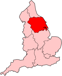 Yorkshire and the Humber region shown within England |
|
| Geography | |
|---|---|
| Status | Region |
| Area — Total |
Ranked 5th 15,420 km² 5,953 sq mi |
| NUTS 1 | UKE |
| Demographics | |
| Population — Total — Density |
Ranked 6th 5,142,400 (2006) 328/km² |
| GDP per capita | £16,880 (8th) |
| Government | |
| HQ | Leeds / Sheffield |
| Leadership | Local Government Yorkshire and Humber |
| Regional development | Yorkshire Forward |
| European parliament | Yorkshire and the Humber |
| Website | |
Yorkshire and the Humber is one of the nine government office regions of England. It covers most of the historic county of Yorkshire, along with the part of northern Lincolnshire that was, from 1974 to 1996, within the former shire county of Humberside. The population in 2006 was 5,142,400.
Contents |
Geographical context
| England |
.svg.png) This article is part of the series: |
|
|
|
Government
Law and justice
England in the UK
England in the EU
Local government
|
|
Other countries · Atlas |
See Topographical areas of Yorkshire and Geology of Yorkshire
Geology
In the Yorkshire and the Humber region there is a very close relationship between the major topographical areas and the underlying geology.[1] The Pennine chain of hills in the west is of Carboniferous origin. The central vale is Permo-Triassic. The North York Moors in the north-east of the county are Jurassic in age while the Yorkshire Wolds and Lincolnshire Wolds to the south east are Cretaceous chalk uplands.[1]
Rivers

The region is drained by several rivers. In western and central Yorkshire the many rivers empty their waters into the River Ouse which reaches the North Sea via the Humber Estuary.[2] The most northerly of the rivers in the Ouse system is the River Swale, which drains Swaledale before passing through Richmond and meandering across the Vale of Mowbray. Next, draining Wensleydale, is the River Ure, which joins the Swale east of Boroughbridge. The River Nidd rises on the edge of the Yorkshire Dales National Park and flows along Nidderdale before reaching the Vale of York.[2]
The Ouse is the name given to the river after its confluence with the Ure at Ouse Gill Beck. The River Wharfe, which drains Wharfedale, joins the Ouse upstream of Cawood.[2] The Rivers Aire and Calder are more southerly contributors to the River Ouse and the most southerly Yorkshire tributary is the River Don, which flows northwards to join the main river at Goole. In the far north of the county the River Tees flows eastwards through Teesdale and empties its waters into the North Sea downstream of Middlesbrough. The smaller River Esk flows from west to east at the northern foot of the North York Moors to reach the sea at Whitby.[2]
The River Derwent rises on the North York Moors, flows south then westwards through the Vale of Pickering then turns south again to drain the eastern part of the Vale of York. It empties into the River Ouse at Barmby on the Marsh.[2] To the east of the Yorkshire Wolds the River Hull flows southwards to join the Humber Estuary at Kingston upon Hull. The western Pennines are served by the River Ribble which drains westwards into the Irish Sea close to Lytham St Annes.[2]
The highest point of the region is Whernside, in the Yorkshire Dales, at 737 metres (2,418 ft). The largest freshwater lake is Hornsea Mere in the East Riding of Yorkshire.

Climate
This region of England generally has cool summers and relatively mild winters with the upland areas of the North York Moors and the Pennines experiencing the coolest weather and the Vale of York the warmest. Weather conditions vary from day to day as well as from season to season. The latitude of the area means that it is influenced by predominantly westerly winds with depressions and their associated fronts, bringing with them unsettled and windy weather, particularly in winter. Between depressions there are often small mobile anticyclones that bring periods of fair weather. In winter anticyclones bring cold dry weather. In summer the anticyclones tend to bring dry settled conditions which can lead to drought. For its latitude this area is mild in winter and cooler in summer due to the influence of the Gulf Stream in the northern Atlantic Ocean.
Air temperature varies on a daily and seasonal basis. The temperature is usually lower at night and January is the coldest time of the year and July is usually the warmest month.[3]
Settlements
There are seven cities in Yorkshire and the Humber: Bradford, Kingston upon Hull, Leeds, Ripon, Sheffield, Wakefield and York. There are many other large towns in the area such as Doncaster, Grimsby, Halifax, Huddersfield and Scunthorpe. Leeds is the largest settlement with a metropolitan population of 770,800. Leeds is now one of the largest financial centres in the United Kingdom. Sheffield is the second largest settlement and is a large manufacturing centre. Bradford is the third largest city and was traditionally a textile city, the decline of these industries has left Bradford's economy more diverse. Kingston upon Hull is the main port in the region and also a notable fishing harbour. While cities such as Bradford, Leeds and Sheffield grew during the industrial revolution, there are older cities in the region such as Wakefield and York.
Local government
The official region consists of the following subdivisions:[4]
| Map | Ceremonial county | County/ unitary | Districts |
|---|---|---|---|
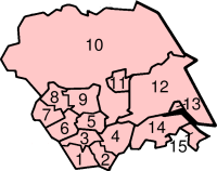 |
South Yorkshire * | 1. Sheffield, 2. Rotherham, 3. Barnsley, 4. Doncaster | |
| West Yorkshire * | 5. Wakefield, 6. Kirklees, 7. Calderdale, 8. Bradford, 9. Leeds | ||
| North Yorkshire (part only) |
10. North Yorkshire † | a.) Selby, b.) Harrogate, c.) Craven, d.) Richmondshire, e.) Hambleton, f.) Ryedale, g.) Scarborough | |
| 11. York U.A. | |||
| East Riding of Yorkshire | 12. East Riding of Yorkshire U.A. | ||
| 13. Kingston upon Hull U.A. | |||
| Lincolnshire (part only) |
14. North Lincolnshire U.A. | ||
| 15. North East Lincolnshire U.A. | |||
Key: shire county = † | metropolitan county = *
History
It was originally called Yorkshire and Humberside, and defined as North Yorkshire, West Yorkshire, South Yorkshire and Humberside. Since then, Humberside has been abolished, and the councils of West and South Yorkshire abolished. The older form of the name is still occasionally seen.
Regional assembly

The Yorkshire and Humber Assembly was a partnership of all local authorities in the region and representatives of various economic, social and environmental sectors. The full Assembly normally met three times a year, normally in February, June and October.
The full Assembly is responsible for providing regional leadership, agreeing regional strategic priorities, directing the development of the Integrated Regional Framework and endorsing key regional strategies. Membership comprises all 22 local authorities in this region, plus 15 Social, Economic and Environmental partners, and the National Parks for planning purposes.[5]

On 31 March 2009, the Assembly was abolished and replaced by Local Government Yorkshire and Humber, which continues to be based in the former Assembly premises in King Street in Wakefield.[6][7]
Yorkshire is one of the two regions (along with the North West) that were expected to have a referendum about the establishment of an elected regional assembly. When the North East region of England rejected having an elected regional assembly in a referendum, the then Deputy Prime Minister John Prescott announced that he would not move orders for other referenda before the relevant provisions expired in June 2005.
European Parliament
The European constituency of Yorkshire and the Humber is coterminous with the English region. After the European Parliament election in June 2009, Yorkshire and the Humber is represented by two Conservative, one Labour, one UKIP, one Liberal Democrat and one BNP MEPs. It is one of two regions in the UK to have elected an MEP from the BNP.[8]
Election results 2009


Elected candidates are shown in bold. Brackets indicate the number of votes per seat won.
| European Election 2009: Yorkshire and The Humber[9][10] | |||||
|---|---|---|---|---|---|
| List | Candidates | Votes | % | ±% | |
| Conservative | Edward McMillan-Scott, Timothy Kirkhope Fleur Butler, Matthew Bean, Nick Burrows, Glynis Frew |
299,802 (149,901) |
24.5 | -0.2 | |
| Labour | Linda McAvan Richard Corbett, Emma Hoddinott, David Bowe, Melanie Onn, Mahroof Hussain |
230,009 | 18.8 | -7.5 | |
| UKIP | Godfrey Bloom Jonathan Arnott, Jason Smith, Toby Horton, David Daniel, Lynette Afshar |
213,750 | 17.4 | +2.9 | |
| Liberal Democrat | Diana Wallis Stewart Arnold, Rebecca Taylor, James Monaghan, Nader Fekri, Neil Poole |
161,552 | 13.2 | -2.4 | |
| BNP | Andrew Brons Nick Cass, Chris Beverley, Marlene Guest, Paul Harris, Trevor Brown |
120,139 | 9.8 | +1.8 | |
| Green | Martin Hemingway, Shan Oakes, Leslie Rowe, Rick Rolt, Kevin Warnes, Lesley Hedges | 104,456 | 8.5 | +2.8 | |
| English Democrats | Michael Cassidy, Joanne Robinson, Peter Davies, David Wildgoose, Paul McEnhill, Geoffery Crossman | 31,287 | 2.6 | +1.0 | |
| Socialist Labour | William Capstick, Linda Sheriden, Stephen Yoxall, Holly Jo Yoxall, Terence Robinson, Christopher Butler | 19,380 | 1.6 | N/A | |
| Christian | Sid Cordle, Andrew McClintock, Angela MacDonald, John O'Brien, Samantha Cauldwell, Rebecca Jones | 16,742 | 1.4 | N/A | |
| NO2EU | Keith Gibson, Celia Foote, Jackie Grunsell, Peter Marsh, Mike Davies, Juliet Marie Boddington | 15,614 | 1.3 | N/A | |
| Jury Team | Barbara Hibbert, Anthony Hooper, Ben Saxton | 7,181 | 0.6 | N/A | |
| Libertas | Antony Devoy, Edward Devoy, Stephen Clark, Diana MacLeod, Trevor Bending, Kathleen Harris | 6,268 | 0.5 | N/A | |
| Turnout | 1,226,180 | 32.3 | -10.3 | ||
Demographics
Population, density and settlements
| Region/County | Population | Population Density | Largest town/city | Largest metropolitan area |
|---|---|---|---|---|
| Yorkshire and the Humber | 5,177,200 | 328/km² | Leeds (761,100) | West Yorkshire Urban Area (1,499,465) |
| West Yorkshire | 2,118,600 | 1,004/km² | Leeds (761,100) | West Yorkshire Urban Area (1,499,465) |
| South Yorkshire | 1,292,900 | 833/km² | Sheffield (530,300) | Sheffield Urban Area (640,720) |
| East Riding of Yorkshire | 587,100 | 137/km² | Kingston upon Hull (257,000) | Kingston upon Hull Urban Area (301,416) |
| North Yorkshire | 1,061,300 | 123/km² | York (193,300) | York (193,300) |
| North Lincolnshire | 159,000 | 188/km² | Scunthorpe (72,660) | Scunthorpe (72,660) |
| North East Lincolnshire | 158,900 | 828/km² | Grimsby (87,574) | Grimsby/Cleethorpes (138,842) |
The region has fewer degree-educated adults than the England average. The region has the UK's highest rate of cancer.
Teenage pregnancy
For top-tier authorities, Kingston upon Hull has the highest teenage pregnancy rate, closely followed by North East Lincolnshire. For top-tier authorities, North Yorkshire has the lowest teenage pregnancy rate. For council districts, Ryedale has the lowest rate, closely followed by Craven. Only North Yorkshire has council districts in the region.
Social deprivation
For multiple deprivation in England, measured by the Indices of deprivation 2007 [12], the most deprived council districts in the region are, in descending order - Kingston upon Hull (11th in England), Bradford (32nd), Doncaster (41st), Barnsley (43rd), North East Lincolnshire (49th), Sheffield (63rd), Wakefield (66th), Rotherham (68th), Kirklees (82nd), Leeds (85th), and Scarborough (97th). These areas are mostly represented by Labour MPs, with a few Conservative MPs representing parts of Leeds (with a Lib Dem MP) and North East Lincolnshire, and all of Scarborough. Apart from Scarborough, they are unitary authorities.
The least deprived districts are, in descending order - Harrogate, Hambleton, Richmondshire, Craven, and Selby - all in North Yorkshire. Like all of North Yorkshire, they are represented by Conservative MPs. At county level, the least deprived areas are, in descending order - North Yorkshire, York and the East Riding of Yorkshire which all have roughly the same level of deprivation, and lower than the majority of England, including Cheshire and Northamptonshire.
The region as a whole is one of the more deprived in England, measured by having far more Lower Layer Super Output Areas (LSOAs) in the 20% most deprived districts than the 20% least deprived districts.
Transport
Transport policy

As part of the national transport planning system, the Regional Assembly is required to produce a Regional Transport Strategy (RTS) to provide long term planning for transport in the region. This involves region wide transport schemes such as those carried out by the Highways Agency and Network Rail.[13] Within the region the local transport authorities plan for the future by producing Local Transport Plans (LTP) which outline their strategies, policies and implementation programmes.[14] The most recent LTP is that for the period 2006–11. In the Yorkshire and The Humber region the following transport authorities have published their LTP online: East Riding of Yorkshire U.A.,[15] Kingston upon Hull,[16] North East Lincolnshire U.A.,[17] North Lincolnshire U.A.,[18] North Yorkshire,[19] South Yorkshire,[20] West Yorkshire[21] and York U.A..[22]
Road

The M62 motorway is Yorkshire's main east-west thoroughfare, and north-south routes are the M1 and the A1, with only the A1 continuing further north. The other main north south road in the region is the A19.[23] The M180 connects the east coast ports via the M18. The A64 road connects areas in the North East of the region to the main body of motorways. The main north-south and east-west routes interchange at a series of junctions to the South and East of Leeds. Leeds and Bradford have inner-city urban motorways, while Sheffield has the Sheffield Parkway and Hull has the Clive Sullivan Way which connect the city centres with the motorway network. Leeds has a inner-ring road network made mostly out of purpose-built motorway stretches which is mostly sub-terrain to the north of the City Centre. Bradford, Huddersfield, Sheffield and York have inner-ring roads made by re-aligning existing roads while Halifax has a town-centre relief scheme made up of the Aachen Way and the North Bridge flyovers.
Rail

The central hubs of the rail network in the region are Leeds, Sheffield and York. The East Coast Main Line passes through Leeds and York whilst the Midland Main Line finishes at Sheffield, with a less regular service to Leeds, operated by East Midlands Trains. East-west routes are the North TransPennine to Manchester, and South TransPennine through Doncaster.[24] Leeds has a fairly extensive commuter network and an electrified section in the North of Bradford provides many commuter services. Sheffield has a smaller commuter rail network and there are also less extensive systems in Doncaster, Huddersfield, Wakefield and Harrogate, which connect the districts of the settlements to the centre by rail. SYPTE and WYPTE subsidise commuters' travel with discount schemes. Tram-trains have also been proposed in the area, however no scheme has yet been approved.
Hull is now connected to the capital with its much-improved First Hull Trains service. North Yorkshire has a skeleton train network, with Scarborough and York being the main destinations.
Mass transit
Only Sheffield has its own mass-transit system, the Sheffield Supertram. Leeds and Bradford have more developed commuter rail systems but lack any mass transit system. The Leeds Supertram was an approved scheme in Leeds, however the funding was pulled and the scheme has been replaced by the proposed Leeds Trolleybus scheme. In the past Bradford, Huddersfield, Kingston upon Hull, Leeds, Rotherham, Sheffield and York have all had mass-transit systems.
Air

Airports in the region are Leeds Bradford International Airport at Yeadon, Robin Hood Airport Doncaster Sheffield near Doncaster and Humberside Airport near Brigg in North Lincolnshire. Leeds Bradford International Airport is the largest in the region by passenger numbers, Robin Hood boasts the longest runway of any airport in the region and Humberside Airport boasts an active heliport.
Sheffield Airport formerly served the city of Sheffield, however the airport struggled to attract many scheduled services and closed followung the opening of Robin Hood Doncaster Sheffield Airport.
Lying outside of the region Durham Tees Valley Airport serves the northernmost areas of the region, and there are day and night direct rail connections from the region to Manchester Airport.[25] National Express coach services also run directly to London Heathrow Airport from the region.
Water

Hull has daily ferries to Zeebrugge and Rotterdam.[26]. Hull also has a large freight port and an active fishing port. Immingham carries much freight transport via DFDS Tor Line and the Stena Line. Goole is Britain's most inland port and is used mostly for importing commodities such as coal and timber.
The region also has a canal network. The Leeds and Liverpool Canal links West Yorkshire with the North West and the Aire and Calder Navigation links Leeds and the coal fields of West and North Yorkshire with the ports to the East of the region. There are also several smaller canals in the region, often built for quite specific purposes. Many stretches of the smaller canals in the region have been backfilled.
Economy

Yorkshire Forward is the Regional Development Agency charged with improving the Yorkshire and Humber economy, where some 270,000 businesses contribute to an economy worth in excess of £80 billion. With over 5 million people living in the region it ranks alongside some small countries including Ireland, Greece, Norway and Singapore.[27] The region has the second lowest rate of GVA in England. However Leeds has a much higher average GVA than most of South Yorkshire.
Yorkshire in the past has been synonymous with mining. Many pits closed in the 1990s, with only two in the Pontefract area left at Kellingley and Sharlston. In South Yorkshire, there is Maltby Main Colliery and Hatfield Colliery at Stainforth. The NUM was very Yorkshire-dominated. Coal still plays a part in the economy - there are three large power stations along the Aire Valley, with Drax being the second largest in Europe with 3,945 MW of capacity. The distribution area once looked after by the regional electricity company Yorkshire Electricity is now looked after by YEDL, owned by CE Electric UK.
East and North

Scunthorpe is where steel is smelted by Corus, and where Golden Wonder crisps are made. Grimsby is home of Britain's fishing industry, and has many frozen food factories such as Young's Bluecrest. There are two large oil refineries at Immingham, and a BP chemical works at Saltend in Hull. Croda International, the chemical company, is in East Cowick. Nestlé in the UK are based in York, with operations in Halifax, as is Persimmon plc, Portakabin and National Express East Coast. Smith & Nephew and Reckitt Benckiser medical and household products companies originated in Hull, and still have large factories there. Heron Frozen Foods is based there near St Andrew's Quay, and Cranswick plc are a food-processing company based in the north of Hull. Aunt Bessie's is a large food company in the west of Hull near the A63 and Hessle. Comet, who originated there, have some main offices on George Street. Seven Seas, owned by Merck KGaA, make cod liver oil and multivitamins is on the A1033 in Marfleet. Fenner plc is in Hessle and BAE Systems Military Air Solutions (former Blackburn Aircraft) make the Hawk at Brough. There are many RAF bases in North Yorkshire, close to the A1, Catterick Garrison is the largest army base in Europe near Richmond, and the Defence School of Transport Leconfield is near Beverley. The Canadian McCain Ltd has been in Scarborough in 1969; AlphaGraphics UK is based there. Skipton Building Society is in Skipton. Richmond Foods is based in Leeming Bar which owns Dalepak, but has its main ice cream factory in Cross Gates, Leeds (now owned by R&R Ice Cream). John Smith's Brewery is at Tadcaster, which is destined to start brewing Newcastle Brown Ale, and Samuel Smith Brewery. At Masham, there is the Theakston Brewery and the Black Sheep Brewery. Quorn is made in Stokesley by Stokesley by Marlow Foods.
West and South

Leeds is now a centre of financial services companies,[28][29] with Direct Line[30] and First Direct[31] based there, as well as Asda,[32] Northern Foods,[33] Arla Foods UK (maker of Lurpak). The Green Flag roadside recovery firm has its main call centre (in Farsley). HSBC opened their first UK call centre in the city, taking advantage of its advanced communications network which also led to the founding of Freeserve in Leeds. The Department of Health has a large administration operation at Quarry House, a local landmark. The Waddingtons board game company was founded in Leeds, as was the Burton tailoring company (the Burton Group became the Arcadia Group) and M & S. The Tetley's Brewery will be moving operations to Northampton (Carlsberg) in 2011. Optare make buses in Cross Gates. Dr. Oetker products are made at Colton near the M1 junction and Sherburn-in-Elmet. Aramark UK is in West Park, Leeds. Unilever have their aerosol division at Whinmoor, in north-east Leeds, administrated by Lever Fabergé. It claims to be the largest aerosol factory in the world, and has their research centre, and makes Impulse, Lynx, Dove and Sure.
Morrisons is based in Bradford, as are Club 18-30, Provident Financial, Hallmark Cards UK, Seabrook Potato Crisps, Safestyle UK, Yorkshire Building Society, Stylo, the Grattan[34] catalogue retailer, and Yorkshire Water. Abbey (soon to be Santander) has its savings division there. The Halifax bank (former Building Society) is based in Halifax, the Yorkshire Bank and Leeds Building Society in Leeds, and the Bradford & Bingley in Bingley. Ciba Specialty Chemicals (former Allied Colloids) is in Low Moor. Fox's Biscuits (part of Northern Foods) and Cattles are in Batley. Poundstretcher is in Deighton near Huddersfield. The British Library is sited at Thorpe Arch near Wetherby, home of Goldenfry. Denso Marston Ltd make car radiators in Shipley. David Brown Ltd. is in Lockwood in Huddersfield; this company owned Aston Martin from 1947–72 and is the company is now part of Textron. Cummins Turbo Technologies (former Holset) and Graham Group are also in Huddersfield. Hickson & Welch (owned by Arch Chemicals) were in Castleford and closed in 2005. Clariant UK, the chemical company, is in Yeadon. Pace plc is in Saltaire. WABCO Vehicle Control Systems UK (air brakes) is in Morley. Netto UK (now owned by Asda) is in South Elmsall. Nestle make Toffee Crisp and After Eight in Castleford. Haribo makes liquorice and Pontefract cakes in Pontefract. Ardagh Glass UK is at Knottingley, with sites at Monk Bretton and Wheatley (Doncaster). Coca-Cola UK claim to have the largest soft drinks factory in the world at Outwood, which was built in 1989, and produces 6,000 cans and 1,650 bottles a minute (over 100 cans a second); Card Factory is nearby.

Sheffield is known for its steel industry, which has declined in recent years. Little Chef are based there, in Carbrook near the Don Valley Stadium. SIG plc and Stanley Tools UK are at the city airport. Cadbury UK (formerly Bassett's) make liquorice allsorts in the north of Sheffield; it is Cadbury's Gum & Liquorice division. Plusnet and Jobcentre Plus are in the city centre. Rosebys were in Rotherham, before 2008, and KP make their nuts in Eastwood, to the north of the town. Mr Kipling is based at Carlton just north of Barnsley, and makes Battenberg cakes there. Galpharm International and Koyo Bearings are at Dodworth near Barnsley. DFS is at Adwick le Street near the A1/A638 junction. Wabtec Rail make railway air brakes near Doncaster railway station. DB Schenker Rail (UK) (former EWS) is on the A6182 in the south of Doncaster. Ronseal is based in Chapeltown in Sheffield. Morphy Richards and Roberts Radio are based between Swinton and Mexborough. Maplin Electronics is based on the former site of Manvers Main Colliery in Wath-upon-Dearne.
Sport
Football
The region is home to numerous Premier League and Football League clubs. Leeds United, Sheffield Wednesday and Huddersfield Town are the most successful clubs in the region in terms of trophies won, each winning 9, 9 and 5 major trophies respectively. Leeds United are the most successful club in terms of European appearances and success, they have also been the UEFA coefficient Top Club on 3 occasions, more than any other English club.
Here is a list of the Premier League and Football League clubs in the region ranked in their final league position in the 2009–10 season.
- Hull City (19th in the Premier League[35] – relegated to the Championship)
- Sheffield United (8th in the Championship[36])
- Doncaster Rovers (12th in the Championship[36])
- Barnsley (18th in the Championship[36])
- Scunthorpe United (20th in the Championship[36])
- Sheffield Wednesday (22nd in the Championship[36] – relegated to League One)
- Leeds United (2nd in League One[37] – promoted to the Championship)
- Huddersfield Town (6th in League One[37] – qualified for play-offs)
- Rotherham United (5th in League Two[38] – qualified for play-offs)
- Bradford City (14th in League Two[38])
- Grimsby Town (23rd in League Two[38] – relegated to the Conference National)
Education
There are 15 Local Education Authorities in the Yorkshire and Humber region.[39] The schools in each authority are listed in the following -

- List of schools in Barnsley
- List of schools in Bradford
- List of schools in Calderdale
- List of schools in Doncaster
- List of schools in the East Riding of Yorkshire
- List of schools in Hull
- List of schools in Kirklees
- List of schools in Leeds
- List of schools in North East Lincolnshire
- List of schools in North Lincolnshire
- List of schools in North Yorkshire
- List of schools in Rotherham
- List of schools in Sheffield
- List of schools in Wakefield
- List of schools in York
Secondary education
Schools are mostly comprehensive, with some grammar schools in North Yorkshire, Calderdale and Kirklees.[40] The schools in Hull perform the second-worst in England at GCSE[41] after Knowsley in Merseyside. To Hull's credit, five schools in its LEA get above-average GCSE results whereas Knowsley has none. Also at GCSE, schools in Barnsley, Bradford, and Doncaster have low-achieving results with Barnsley the worst of these. All four of these areas coincidentally have an above-average teenage pregnancy problem. For the metropolitan areas, Calderdale and Wakefield consistently perform the best, with Wakefield slightly under the England average and Calderdale slightly above. Rotherham has the best results in South Yorkshire. York and North Yorkshire consistently perform the best at GCSE in the region, and with the East Riding of Yorkshire have results above the UK average.
Schoolchildren in Kingston upon Hull are most likely not to pass any GCSEs - over 6% with Bradford having a similar proportion, closely followed by Sheffield and North East Lincolnshire. The East Riding of Yorkshire and North Lincolnshire have the fewest not passing any GCSEs, followed by York.
For OFSTED inspections across England, the region has the highest proportion of schools (2.7%) with bad behaviour and the lowest proportion (16.3%) of schools with good behaviour. South West England has the best behaving schoolchildren. Inside the region, Hull has the highest proportion (16.7%) of schools with bad behaviour - the worst in England (Wandsworth and Bristol come joint second) - and York schools have the highest proportion (30%) of schools with outstanding behaviour.
At A-level North Lincolnshire, Kirklees, Wakefield, Calderdale, Hull, York and North Yorkshire perform quite well with Kirklees consistently being the best by a large margin, all having results above the England average. The excellent Kirklees result is due to Greenhead College in Huddersfield, and North Lincolnshire's results are due to the John Leggott College, also a sixth form college. The districts of South Yorkshire perform the least in the area at A-level with Rotherham having the best results in this area, slightly below-average, and the other three districts achieve similar results, much lower than those in the former districts of Humberside. Leeds and Bradford now get the lowest results in West Yorkshire.
For both A-level and GCSE, Barnsley and Bradford are very low performing, with Barnsley getting the lowest A-level results in the region. Hull and northern Lincolnshire have a wide socio-economic diversity – many under-achieving pupils at 16 but with high performers at A-level. Hull, although much worse at GCSE, outperforms the East Riding of Yorkshire at A-level.[42]
School children in North Yorkshire (with York and Kirklees) are the most likely to go to university - they also get the best A level results, and those in the East Riding of Yorkshire are likely to go to university, but get lower overall A level results.
Top twenty five state schools in Yorkshire and the Humber (2009 A-level results)


- 1. Ermysted's Grammar School, Skipton (1128)
- 2. Ripon Grammar School
- 3. Heckmondwike Grammar School
- 4. Greenhead College, Huddersfield
- 5. Crossley Heath Grammar School, Halifax
- 6. Skipton Girls' High School
- 7. St. Mary's School, Menston
- 8. Fulford School
- 9. Huntington School, York
- 10. Notre Dame High School (Sheffield)
- 11. Bingley Grammar School
- 12. Malton School
- 13. Shelley College
- 14. The Hayfield School, Doncaster
- 15. Penistone Grammar School
- 16. The McAuley Catholic High School, Doncaster
- 17. Guiseley School
- 18. Ilkley Grammar School
- 19. Wath Comprehensive School
- 20. St. Aidan's & St. John Fisher Associated Sixth Form, Harrogate
- 21. Harrogate Grammar School
- 22. NEW College, Pontefract
- 23. Franklin College, Grimsby
- 24. Joseph Rowntree School, New Earswick
- 25. Tollbar Business and Enterprise College, New Waltham (852)
Colleges
There are twenty seven FE colleges. The main four colleges are Bradford College, Grimsby Institute, Doncaster College and Hull College.

Universities

There are nine universities and three higher education colleges in Yorkshire and the Humber, along with (in 2007) 27 Further Education colleges teaching some Higher Education courses.[44]
The Krebs Cycle was discovered at the University of Sheffield in 1937. Liquid crystal displays were developed by the University of Hull in 1972, in conjunction with the Royal Radar Establishment in Worcestershire. Low fat spreads were developed at the University of Leeds (in conjunction with Unilever) in the 1980s.
The University of Leeds is the largest in the region with 33,000 students, and has the most funding, especially for research. The University of Sheffield is not too far behind, with similar amounts spent on research. The University of York gets much less funding than Leeds and Sheffield, but has quite a high research grant for its size, about half that of Leeds or Sheffield. The other universities do not have large research grants. Leeds and Sheffield have around twice as much total income than any other university. York and Bradford are the two smallest universities.
For first degree students at universities in the region, 27% are native to the region, 16% are from North West England and 11% from the East Midlands; 48% are from Northern England and around 25% from Southern England. Access to the M62 determines the regions from which the region's universities' students originate from - the nearer there are to the motorway the easier it is to study in the Yorkshire and Humberside region. For first degree students native to the region, 43% stay in the region, 16% go to the North West, 11% to the North East and 11% to the East Midlands; just under 10% go to Southern England, with 70% staying in Northern England.
Once graduated, 53% of the region's universities' graduates (native and non-native) stay to find work in the region, with around 10% moving to the North West (Manchester); 70% stay in Northern England, with 20% going to Southern England.
Local media

- Local BBC television comes from Leeds and Hull. Yorkshire Television is on Kirkstall Road to the west of Leeds city centre, which broadcasts Calendar and some national programming. Channel 4 broadcasts some of its flagship programming from Kirkstall, including Countdown.
- BBC Radios Humberside, Leeds, Sheffield and York.
- Local commercial stations include Dearne FM (Barnsley), The Pulse of West Yorkshire (Bradford), Trax FM (Doncaster), Compass FM (Grimsby), 97.2 Stray FM (Harrogate), Home 107.9 (Huddersfield), Viking FM (Hull), Rother FM, 96.3 Radio Aire (Leeds), Yorkshire Coast Radio (Scarborough), Hallam FM (Sheffield), Fresh Radio (Skipton), Real Radio (Tingley), Ridings FM (Wakefield), Galaxy Yorkshire and Minster FM (York).
- Local newspapers are the Bradford Telegraph and Argus, Evening Courier, Huddersfield Examiner, Hull Daily Mail, Scarborough Evening News, Scunthorpe Telegraph, Sheffield Star, The Press (York), Wakefield Express, Yorkshire Evening Post and Yorkshire Post.[45][46]
- Yorkshire and Humberside are very supportive in their approach to theatre and performance festivals and hold regional championships for young performers every 2 years. The championship is sectioned in Dance, Music and Speech & Drama. The most recent championship was held on Saturday 8 September, at St Margaret's Church Hall, Horsforth in Leeds. 16 year-old Nuthana Prathivadi, of Halifax, took the Dance Champion title; Helen Wilson, of Harrogate, titled Music Champion and with 17-year old Lee Peart, of Cleethorpes, winning the Speech & Drama championship.[47]
References
- ↑ 1.0 1.1 "Yorkshire Geology". Genuki.org. http://www.genuki.org.uk/big/eng/YKS/. Retrieved 2007-10-24.
- ↑ 2.0 2.1 2.2 2.3 2.4 2.5 British Canoe Union, Yorkshire and Humberside Region, Access and Recreation Committees ; prepared by Mike Twiggs and David Taylor. (1992). Yorkshire Rivers: A Canoeists Guide. Menasha Ridge Press. ISBN 978-1871890167. OCLC 27687324.
- ↑ "English Climate". Met Office. http://www.metoffice.gov.uk/climate/uk/location/england/. Retrieved 2008-05-03.
- ↑ "Local Authorities". Government Office for Yorkshire and the Humber. April 2008. http://www.gos.gov.uk/goyh/ourregion/las/. Retrieved 2008-05-06.
- ↑ "What is the Assembly and how does it work?". http://www.yhassembly.gov.uk/About%20Us/What%20is%20the%20Assembly%20and%20how%20does%20it%20work/. Retrieved 2008-05-12.
- ↑ Smithard, Tom (2009-03-31). "The short life and changing times of a people's parliament that never was". Yorkshire Post. Johnston Press Digital Publishing. http://www.yorkshirepost.co.uk/features/The-short-life-and-changing.5124376.jp. Retrieved 2010-01-09.
- ↑ "Yorkshire and Humber Assembly". http://www.yhassembly.gov.uk/. Retrieved 2008-05-12.
- ↑ "BNP secures two European seats". BBC News Online. BBC. 2009-06-08. http://news.bbc.co.uk/1/hi/uk_politics/8088381.stm. Retrieved 2009-06-08.
- ↑ "European Parliamentary Election Thursday 4th June 2009 Yorkshire and The Humber Region Statement of Parties Nominated" (PDF). http://www.europarl.org.uk/sites/all/modules/tinymce/tinymce/jscripts/tiny_mce/plugins/filemanager/files/elections/candidates/pdf/official/YorkshireandtheHumber.pdf. Retrieved 2010-01-09.
- ↑ "European Election 2009: Yorkshire and the Humber". BBC News Online. BBC. 2009-06-07. http://news.bbc.co.uk/1/shared/bsp/hi/elections/euro/09/html/ukregion_38.stm. Retrieved 2010-01-09.
- ↑ Office for National Statistics. (April 2008). "Fact Files: Yorkshire and The Humber > Yorkshire and The Humber". Government Office for Yorkshire and the Humber. http://www.gos.gov.uk/goyh/factgoyh/Yorkshireandthehumber/. Retrieved 2008-05-06.
- ↑ LSOA deprivation data
- ↑ "Regional Transport Strategy: the National Picture". Government Office for Yorkshire and The Humber. http://www.gos.gov.uk/goyh/transp/rts/?a=42496. Retrieved 2009-05-07.
- ↑ "The LTP Process". Department for Transport. http://www.dft.gov.uk/pgr/regional/ltp/theltpprocess. Retrieved 2009-05-07.
- ↑ "East Riding of Yorkshire 2006-11 Local Transport Plan". East Riding of Yorkshire Council. http://www.eastriding.gov.uk/az/face_service_live_proc?p_aplaws_ref=118&p_category_ref=2174&p_app_ref=&p_spec_ref=. Retrieved 2009-05-07.
- ↑ "Hull 2006-11 Local Transport Plan". Hull City Council. http://www.hullcc.gov.uk/portal/page?_pageid=221,161568&_dad=portal&_schema=PORTAL. Retrieved 2009-05-07.
- ↑ "North East Lincolnshire 2006-11 Local Transport Plan". North East Lincolnshire Council. http://www.nelincs.gov.uk/transportstreets/transportplanning/Local+Transport+Plan.htm. Retrieved 2009-05-07.
- ↑ "North Lincolnshire 2006-11 Local Transport Plan". North Lincolnshire Council . http://www.northlincs.gov.uk/NorthLincs/Transportandstreets/transportplanning/LocalTransportPlan/. Retrieved 2009-05-07.
- ↑ "North Yorkshire 2006-11 Local Transport Plan". North Yorkshire County Council. http://www.northyorks.gov.uk/index.aspx?articleid=3256. Retrieved 2009-05-07.
- ↑ "South Yorkshire 2006-11 Local Transport Plan". South Yorkshire Integrated Transport Authority. http://www.southyorks.gov.uk/index.asp?id=509. Retrieved 2009-05-07.
- ↑ "West Yorkshire 2006-11 Local Transport Plan". West Yorkshire Local Transport Plan Partnership. http://www.wyltp.com/. Retrieved 2009-05-07.
- ↑ "2006-11 Local Transport Plan". City of York Council. http://www.york.gov.uk/transport/Local_transport_plan/LocalTransportPlan/. Retrieved 2009-05-07.
- ↑ Philips Motoring Atlas:Britain. London: Philips. 2005.
- ↑ "Network Rail". www.networkrailmediacentre.co.uk. http://www.networkrailmediacentre.co.uk/Content/Detail.asp?ReleaseID=3919&NewsAreaID=2&SearchCategoryID=2. Retrieved 2008-10-05.
- ↑ "Yorkshire travel information centre, Airlines, Airports, Ferries, Canal Holidays, Yorkshire, Northern England". www.yorkshirenet.co.uk. http://www.yorkshirenet.co.uk/links-travel.asp?showsub=airlines,airports,ferries,canal%20holidays. Retrieved 2008-10-05.
- ↑ "Hull to Zeebrugge ferries to Belgium - P&O Ferries". www.poferries.com. http://www.poferries.com/tourist/content/pages/template/routes_hull_-_zeebrugge_routes_-_hull_-_zeebrugge.htm;jsessionid=ac10182d30d8e78b0c6e70f44aa9b662eecdf72aec4f.e38Mc34Ma3iKa40Ma3aObxyRbxyLe6fznA5Pp7ftolbGmkTy?WT.srch=1?TYPE=aff. Retrieved 2008-10-05.
- ↑ "Yorkshire Forward". http://www.yorkshire-forward.com/www/index.asp. Retrieved 2008-05-12.
- ↑ "Major study predicts continued growth for financial services in Leeds - Yorkshire Forward". www.yorkshire-forward.com. http://www.yorkshire-forward.com/www/view.asp?content_id=934&parent_id=1224. Retrieved 2008-10-05.
- ↑ "Discovering Leeds - Industrial Leeds". www.leeds.gov.uk. http://www.leeds.gov.uk/discover/discovery.asp?page=2003219_348858059&topic=2003724_752773464&subsection=2003910_153240383. Retrieved 2008-10-05.
- ↑ "Direct Line House, Leeds". www.leedsonline.co.uk. http://www.leedsonline.co.uk/street/Direct_Line_House/. Retrieved 2008-10-05.
- ↑ "First Direct, Leeds, West Yorkshire, LS10 - Contact Details". iWest Yorkshire. http://www.iwestyorkshire.co.uk/profile/26754/Leeds/First-Direct/. Retrieved 2008-10-05.
- ↑ "Corporate Watch : Asda Wal-Mart : Who, Where, How Much?". www.corporatewatch.org.uk. http://www.corporatewatch.org.uk/?lid=801. Retrieved 2008-10-06.
- ↑ "Corporate Watch : Northern Foods Plc : Who, Where, How Much?". www.corporatewatch.org.uk. http://www.corporatewatch.org.uk/?lid=243. Retrieved 2008-10-06.
- ↑ "Grattan - a background history on Grattan Catalogues". www.thecatalogshop.co.uk. http://www.thecatalogshop.co.uk/catalogue-history/grattan.php. Retrieved 2008-10-05.
- ↑ "Statistics: Premier League". Premier League. Premier League. 2010. http://www.premierleague.com/page/Statistics/0,,12306,00.html. Retrieved 2010-05-10.
- ↑ 36.0 36.1 36.2 36.3 36.4 "League Tables: The Football League (Championship)". The Football League. The Football League Limited and FL Interactive Limited. 2010. http://www.football-league.co.uk/page/DivisionalLeagueTable/0,,10794~20097,00.html. Retrieved 2010-05-10.
- ↑ 37.0 37.1 "League Tables: The Football League (League 1)". The Football League. The Football League Limited and FL Interactive Limited. 2010. http://www.football-league.co.uk/page/DivisionalLeagueTable/0,,10794~200925,00.html. Retrieved 2010-05-10.
- ↑ 38.0 38.1 38.2 "League Tables: The Football League (League 2)". The Football League. The Football League Limited and FL Interactive Limited. 2010. http://www.football-league.co.uk/page/DivisionalLeagueTable/0,,10794~200926,00.html. Retrieved 2010-05-10.
- ↑ "Region - Yorkshire & the Humber". Dcsf.gov.uk. http://www.dcsf.gov.uk/rsgateway/region3.shtml. Retrieved 2009-05-22.
- ↑ "Schools Web Directory UK". www.schoolswebdirectory.co.uk. http://www.schoolswebdirectory.co.uk/. Retrieved 2008-10-01.
- ↑ "Hull City Council : School performance". www.hullcc.gov.uk. http://www.hullcc.gov.uk/portal/page?_pageid=221,137365&_dad=portal&_schema=PORTAL. Retrieved 2008-10-01.
- ↑ "Schools Web Directory UK". www.schoolswebdirectory.co.uk. http://www.schoolswebdirectory.co.uk/maps.php?region=yo. Retrieved 2008-10-01.
- ↑ "League Tables - English Secondary Schools 2007". BBC. 26 September 2008. http://news.bbc.co.uk/1/hi/education/league_tables/default.stm. Retrieved 2008-10-01.
- ↑ http://www.hefce.ac.uk/pubs/hefce/2007/07_18/outputYH.pdf HEFCE
- ↑ "Yorkshire Media Centre, Yorkshire, Northern England". www.yorkshirenet.co.uk. http://www.yorkshirenet.co.uk/media.htm. Retrieved 2008-10-05.
- ↑ "Yorkshire UK News Media - Yorkshire newspapers, magazines, radio and TV stations". www.mondotimes.com. http://www.mondotimes.com/1/world/uk/175. Retrieved 2008-10-05.
- ↑ "arts funding in yorkshire and the humber 2005/06" (PDF). Arts Council England. http://www.artscouncil.org.uk/documents/publications/artsfundingyorkshire0506_phpvgWpu8.pdf. Retrieved 2008-10-05.
External links

- Government Office for Yorkshire and the Humber
- Yorkshire and Humber Assembly
- Yorkshire Forward
- Yorkshire and Humber Faiths Forum
- Yorkshireeurope - Yorkshire and Humber working in Europe
- Yorkshire and Humber Assembly Information Pack
- The Northern Way
|
|||||
|
|||||
|
|||||||||||||||||||||||||||||||||||||||||||||||